THE AIRLINE PILOTS FORUM & RESOURCE
Rain, Freezing Rain, Snow and Hail |
| Source: Excerpt from The Book " Weather " |

|
| Rain | Freezing Rain | Snow | Hail |
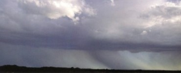
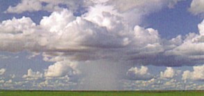
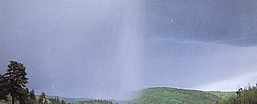
Rain is defined as precipitation that reaches the ground in liquid form. Initially, rain forms in a cloud as either water droplets or ice crystals. These then grow large enough to fall from the cloud under the influence of gravity, the ice crystals melting on their way to the ground. Sometimes, water droplets or ice crystals fall from a cloud but evaporate in mid-air. This creates an effect that resembles a dark fringe hanging from the cloud base. This phenomenon is known as virga, and it occurs when there is a deep layer of dry air, or a shallow layer of extremely dry air, beneath the cloud. Because virga does not reach the ground, it cannot be classified as precipitation. However, the evaporation that produces virga increases the water vapor content in the layer of dry air, making it increasingly likely that subsequent falls will reach the ground. Classifying Rain Rain that does reach the ground can be defined in a number of ways. In the United States, liquid precipitation is classified on the basis of the size of the raindrops and the extent of the associated visibility. Precipitation that consists of raindrops that are less than 1/50 inch (0.065 mm) in diameter and fall close together is defined as drizzle. Drizzle is categorized as light, moderate, or heavy depending on the visibility. Larger raindrops, or smaller drops that are widely separated, are classed as rain, which is defined as light, moderate, or heavy according to the amount that falls and the visibility. While this system is precise, the amateur weather-watcher is unlikely to make use of it. A simpler and more practical distinction, adopted in some other countries, defines the type of precipitation according to the cloud that produces it. Under this system, liquid precipitation is classed as either rain or showers. Rain refers to falls from stratiform clouds, particularly stratus and altostratus. These clouds normally cover a wide area, so rainfall from stratiform clouds tends to be widespread and relatively long-lasting. Showers, on the other hand, refers to falls from cumuliform clouds. These falls tend to be localized, and may only last for a minute or so. However, some showers may be heavy, particularly when associated with thunderstorms. Dry spells between showers normally last much longer than the shower itself. However, if there is a lot of cloud about, a number of showers may occur with only short dry spells between them. Flooding may be caused by both rain from stratiform clouds and showers from cumuliform clouds. Persistent rain may lead to flooding over an extensive area, while heavy showers are more likely to cause flash floods. |
In wintry conditions, when temperatures at cloud level are below zero, any water droplets that fall from clouds will be supercooled. This means that they are likely to freeze as soon as they encounter a colder layer of air or a surface whose temperature is below 32° F (0° C). Precipitation that freezes in either of these ways is known as freezing rain. In the former case, the rain turns into tiny pellets of ice in mid-air. In the United States, this type of frozen rain is known as sleet. In Australia and the United Kingdom, it is referred to as ice pellets, while sleet is used to describe a fall of partially melted snow. Probably the most important distinction to be made between the various types of frozen precipitation is the difference between the ice pellet form of frozen rain and hail. The latter only forms in a thundercloud, while freezing rain may fall from any cloud that can produce rain, provided that the air is cold enough.
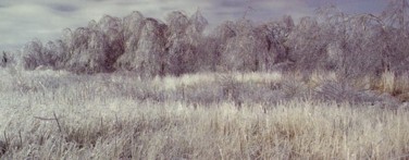
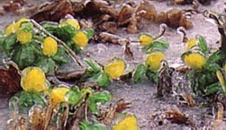
Surface Conditions When large supercooled droplets strike subfreezing ground, they tend to spread out on impact before freezing, coating surfaces with a layer of clear ice known as glaze (as shown in the picture on right). This type of ice can produce hazardous conditions, making it extremely difficult to drive or even walk. A heavy downpour in these conditions is known as an ice storm. The accumulation of glaze on exposed objects as a result of an ice storm can cause significant structural damage --- it has been known to bring down overhead wires and tree branches.
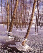
When very small supercooled droplets strike subfreezing ground, they tend to freeze immediately on impact, trapping air between them. This produces an opaque, granulated coating of ice, known as rime, which is not as slippery as glaze. (Picture on the right shows supercooled droplets which have frozen on impact with the ground). Ice pellets normally shatter on impact, scattering ice debris across the ground. However, if the ice pellets have not completely frozen through, water from inside the pellets may spread across the ground, forming a glaze as it freezes. If carried by a strong wind, ice pellets can sting exposed skin, causing great discomfort. Once glaze has formed, it normally thaws in a few hours. However, there have been occasions when glaze has persisted for days. The most extreme case on record was during the winter of 1969, in Connecticut, in the United States, when glaze remained on trees for six weeks. While freezing rain can be very inconvenient, the greatest associated hazard is ice accretion on aircraft and boats. If an airplane flies through a supercooled cloud, ice will quickly form on its body and wings, altering its speed and aerodynamics. A substantial build-up of ice on the masts of a sailing boat at sea can cause the vessel to capsize. |
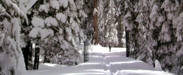
A landscape draped in a thick mantle of fresh snow is one of nature's most magnificent sights. Snow is common during the winter months in Europe and North America and is a permanent feature of many mountaintops throughout the world. Mount Kilimanjaro, in Tanzania, maintains a permanent cap of snow despite being only 3 degrees south of the equator. Snow begins as ice crystals that form a cloud when water vapor freezes around minute solid particles in the middle and upper levels of the atmosphere, where the temperatures are well below 32° F (0° C). The individual ice crystals gradually bond, forming snowflakes. Once the snowflakes are heavy enough, they fall to the ground. Ice crystals form in a vast array of shapes depending on the temperature and humidity of the surrounding air mass. With the invention of the microscope, the beauty and diversity of ice crystals became apparent for the first time. An American farmer, William Bentley (1865-1931), photographed thousands of magnified ice crystals, and noted that, although there were identifiable crystal systems, no two crystals were identical. In order to study individual crystals, Bentley had to catch the flakes on a velvet-covered tray, tease the crystals apart with a probe, and smooth them out with a feather. The Temperature of Snow Often snow that falls from a cloud melts as it descends, and reaches the ground as rain. However, the melting process extracts latent heat from the surrounding air, causing the air temperature to cool and making it increasingly likely that subsequent snow will reach the ground. Interestingly, the ideal conditions for snow are temperatures close to and just below zero, rather than colder temperatures. This is because the warmer the snow, the more moisture it will contain, and hence the bigger the flakes will be; and because a temperature close to 32° F (0° C) will allow snow to melt, refreeze, and combine in larger flakes. As a result, very slight changes in temperature can mean the difference between snow or rain, making accurate forecasts difficult. Snow can settle on the ground in a variety of forms, depending on wind, temperature, and humidity. Air temperatures well below freezing produce small, powdery flakes that provide ideal conditions for skiing. Snowflakes that form in temperatures closer to 32° F (0° C) are larger and wetter and tend to stick to surfaces. Strong winds may pile up snow in hollows and against houses, in what are known as snowdrifts. Once snow has settled, it may melt and refreeze, becoming harder and more compacted in the process. In mountainous areas, a build-up of snow can cause avalanches, which may sweep down steep slopes, destroying everything in their path. This is often the result of new falls of loose, powdery snow settling on a hard base formed by earlier falls. More common, but just as dangerous, are blizzards. These are caused by a combination of heavy snow, low temperatures, and strong winds, and can bring cities to a standstill. An associated phenomenon is a whiteout, when heavy snow and low cloud render the ground and the sky indistinguishable, making navigation impossible. In countries where these conditions occur, blizzard warnings are among the most important weather forecasts issued. Accurate forecasts can reduce fatalities by ensuring people are indoors by the time a blizzard occurs, and by alerting emergency services before conditions deteriorate. |
Perhaps the most destructive form of precipitation is hail. These frozen lumps of ice are produced by thunderstorms and are responsible for injury and property damage worth millions of dollars around the world each year. Hail is produced when supercooled water droplets are circulated within the updraft area of a cumulonimbus cloud. As the droplets pass through areas of differing temperature and humidity, different types of ice build up on them. Where temperatures are just below freezing and there are many supercooled water droplets, layers of clear ice form. In colder parts of the cloud, where there are fewer and smaller water droplets, freezing is so rapid that bubbles of air are trapped, forming opaque rime ice. This layering effect is enhanced as the hailstone alternately melts and freezes as it encounters warmer and colder air. Most hailstones are around the size of a pea; however, some grow as large as golf balls, or even oranges. The size and number of layers will depend on how long the hailstone remains in the storm --- hailstones consisting of 25 ice layers have been recorded. Hail will eventually fall from the cloud if it becomes too heavy to be supported by the updrafts, if the updrafts weaken, or if it is thrown clear of the updraft area. Hail formation requires the strong updrafts associated with spring and summer storms. However, hail is unlikely to reach the ground in tropical areas as the high temperatures will melt the stones. Hail-producing storms are therefore most common around the middle latitudes, with parts of central North America reporting the highest incidence. Freak Hail Throughout history, there are records of freak hailstorms, producing enormous stones. In 1888, in northern India, baseball-sized hail reportedly killed 250 people, as well as large numbers of livestock. More recently, in 1986, a hailstorm over Bangladesh produced 2.25 pound (1 kg) stones, which killed 92 people. Hail causes a great deal of damage to property. Cars are particularly vulnerable and insurance claims run to hundreds of millions of dollars each year. Hailstorms also present a significant aviation hazard, although the advent of onboard radar has lessened this risk. Signs of hail in an approaching storm include a greenish tinge at the base of the cloud, or a whitening of any rainfall. If hail looks likely, move people and pets indoors. Fortunately, hailstorms tend to be brief events, as they occur in only a small part of a moving storm. |
Acknowledgement: John W. Zillman, William J. Burroughs,
Bob Crowder, Ted Robertson, Eleanor Vallier-Talbot and Richard Whitaker.