THE AIRLINE PILOTS FORUM & RESOURCE
Aerial Trekking in The Northern Areas of Pakistan |
 |
Check out the Photoblog for more pictures
Rarely do you experience a phenomenon so unique, so exhilarating, that it leaves you catching your breath at the sheer spectacle and magnitude of God's boundless beauty.
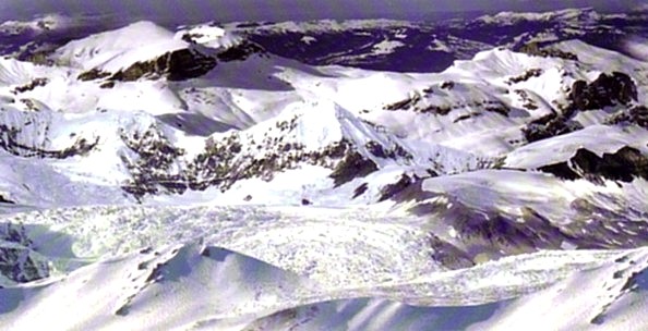
One such indisputably rare experience can be had on board PIA's 90 minute Air safari flight to and along the Karakorams. The thrill of viewing some of the world's highest mountain peaks, along with some of the picturesque valleys, dales, lakes and glaciers from the comfort of your aeroplane seat is a novel, and at the same time a highly stimulating experience, the memory of which lingers long after the flight is over.
Soon after take off from Islamabad, the plane flies directly over the enchanting Northern Areas of Pakistan - over the remote and picturesque valleys of Hunza, Gilgit, Swat, Kaghan, Naran and Chitral - enabling you to marvel at some of the God's most spectacular creations.
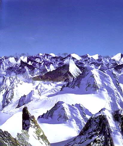
As the aircraft, PIA's Boeing 737, is skillfully maneuvered and controlled by some of the airline's specially trained and high-rated pilots, the passengers are treated to a 'one of a kind' experience - a sky dance of the Karakoram and Hindu Kush ranges which include some of the highest peaks in the world.
You can see the majestic Nanga Parbat (8125m), the beautiful Rakaposhi (7788m) and above all, the spectacular K-2 (the second highest peak in the world) towering above all others at 8611 meters, leaving you simply spellbound.
The invincible majesty, the irrevocable beauty, the awesome splendor - the snow capped peaks, in all their glory and grandeur provide one of the most moving and awe-inspiring moments of your life.
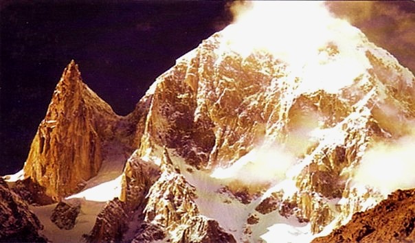
A close aerial view - merely a few kilometers away from the great peaks - beside providing some thrills and chills is, undoubtedly, a wonder that motivates you to a better understanding of the lure and charm that has seduced mountaineers to take on the perilous task of conquering these giants of nature, since time immemorial. A close visual, though intangible, contact with the manifestations of God is a mystical experience that transcends one from the peripheral to the spiritual.
A dance with the clouds in a world that seems to exist in its original form; a natural beauty - untouched, unscathed and unspoiled is a sight that would, certainly move only the nature lovers but also the most cynical amongst us.
The Ultimate Aerial Trek You have entered the land of mega mountains, a vast 84,000 sq km or 33,000 sq miles territory -- larger than Austria and Switzerland combined. The northern region of Pakistan is the meeting point of three of the world's greatest and highest mountain ranges i.e. the Karakorams, the Himalayas, and the Hindu Kush. These ranges consist of hundreds of peaks ranging from 6000 to 8600+ meters above sea-level, including the forbidding and fabulous K-2, the world's second highest mountain regarded as one of the most dangerous peaks by mountaineers everywhere; and the mysterious and lethal Himalayan peak 'Nanga Parbat'. These are known as the Killer Mountains to climbers world wide. Five of the world's 14 highest mountains (over 8000m) are here. [Map Regarding Mountains of Pakistan]. The K2 or 'Chogori' in its native Balti language, is 8611m (or 28,251 ft). The Gasherbrum I or Hidden Peak 8068m, the Broad Peak or Falchan Kangri 8047m and the Gasherbrum II 8035m in the Karakoram range, at the awesome darbar or court of the mountain giants --- the Concordia. The mammoth Baltoro, Biafo and Hispar glaciers flowing like massive frozen rivers in between the giant mountains; and the Rakaposhi, the Disteghil Sar, the Haramosh also in the Karakorams and the fearsome killer, the Nanga Parbat 8125m (or 26,657 ft) in the Himalayas. Over 1500 people have climbed Mount Everest but less than 200 have managed to summit the mighty gargantuan K-2. Much of the Karakorams are in the land of Baltistan accessed from the Northern Area town of Skardu. Whereas the Nanga Parbat is the westernmost mountain -- the Western Anchor -- of the Himalyan range, 200 km away from the rest of its highest peaks in Nepal. This massive nook of the world stretches over 9% of Pakistan's total territory of 888,000 sq km (350,000 sq miles) - extending from China to Afghanistan and Central Asia to Kashmir. The mammoth Siachen, at over 7000m elevation is 75 km long, largest alpine glacier in the world, the Biafo 68 km long, the Baltoro 62 km long, the Batura 58 km long and the Hispar 53 km long, to name just a few of the scores that are found here. Experience a popular environment so like the Arctic and Antarctic, that is often called the 'third pole' of the Earth! The Karakoram is 300 miles long and 60 miles wide, It has 4 peaks higher than 8000 meters, 133 peaks higher than 7000 meters and hundreds of peaks over 6000 meters. The Karakorams begin at Chilinji Pass South East of Wakhjir Pass and each group of mountains in the range is called a Muztagh i.e. Batura, Hispas, Panmah, Baltoro, Siachen, Rimo, Saser. Each Muztagh is named after its major glacier / river system. These 7 Muztaghs are called the greater Karakorams. South of Hispar glacier are called the lesser Karakorams, even though the elevation of 9 of these peaks is greater than 7000 meters, which includes the magnificent, massive, snow clad Rakaposhi as well as Haramosh and Malubiting. There are 14 major peaks in the Batura Muztagh. There are more than 25 major peaks higher than 7000 meters in the Hispar Muztagh including Disteghil Sar (elevation 7884m) Khunyan-Shhish (elevation 7825m) Kanjuit Sar (elevation 7760m) Travior (elevation 7720m) and the Ogre Peak 7300 meters off the Biafo Glacier.
Baltoro Muztagh is the highest and largest Muztagh of the Karakorams; 4 of the summits are greater than 8000 meters namely the primeval pyramid K-2 the second highest peak in the world (8611m). Gasherbrum I (8068m, also called the Hidden Peak since it comes into view only after climbing the Upper Baltoro - 8068m), Gasherbrum II (8035 meters), Broad Peak (8047 meters). 25 peaks in the Baltoro Muztagh are higher than 7000 meters including Gasherbrum III, IV, V, VI, Skyang Kangri, Muztagh Tower and Skilbrum. Muztagh Baltoro also contains rock spires as Payu, Ulibiafo, Cathedral and the Trango group. Masherbrum peak 7831 meters - Masherbrum Muztagh group extending easterly from the Baltoro Glacier with 29 summits greater than 7000 meters i.e. Masherbrum, Chogolisa (7400 meters), Baltoro Kangri, Sia Kangri I, II, III, Link Sar, K-6 and the Marble Peak. The Hindu Kush Range extends westwards 750 miles south of Wakhjir Pass to Koh-e-Baba mountains in North Central Afghanistan and also considered part of the Greater Himalayas. Tirichmir ('tirich' means mountain, 'mir' means king) king of mountains soars to the dizzying height of 7706 meters and is the highest peak of the Hindu Kush. There are 37 peaks greater than 7000 meters all concentrated North of Chitral in the Hindu Kush Range - Istoro--nal, Noshaq, Sanghrar, Shingesk to name a few. There are over 100 peaks greater than 6000 meters in other areas of the Hindu Kush. The Wakhjir Pass is the demarcating boundary between the Hindukush and the Karakorams. The Majestic Nanga Parbat at 8126 meters is the world's nineth highest mountain. Its name means 'Naked Mountain' in Sanskrit. It is called 'Diamir' which means the King of Mountains. It is also known as 'Devil Mountain' and the 'Man Eating Mountain' for having claimed the life of several mountaineers. In addition to the main summit, its 6 summits are above 7000 meters. Front Peak (7910 meters), Silberacken (7510 meters), Rakhiot Peak (7074 meters) and others. The Rakhiot glacier flows from the North side. Vizhin glacier from the South side and Diamir glacier from the West side and the Rupal flank which constitutes the highest mountain wall in the world. The Nanga Parbat is the highest peak of the Punjab Himalayan Range of the Greater Himalayas as distinct from the Karakorams. View the picturesque Fairy Meadows, the graceful Sleeping Beauty, the Satpara Lake, the enchanting Kachura Lakes at Shangrila and the magical Saiful Malook. Also see the awe inspiring sights of Deosai plains, the highest plateau in the world, the alluring Astore valley, the Kidney hills and the haunting horse shoe lake Lalusar. |
Check out the Photoblog for more pictures