THE AIRLINE PILOTS FORUM & RESOURCE
Thunderstorm Lightning Tornadoes and Hurricane |
| Source: Excerpt from The Book " Weather " |

|
| Thunderstorm | Cloud-to-Ground Lightning | Cloud-to-Cloud Lightning |
| Cloud-to-Air Lightning | Tornadoes | Waterspouts |
| Dust Devils | Microbursts | Dust Storms |
| Hurricanes | ||
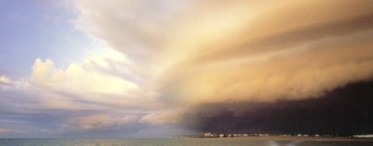
The magnificent anvil-shaped cloud of the mature thunderstorm has long been an object of awe and fascination because of its capacity to unleash devastating rain, wind, hail, and even tornadoes, as well as awesome displays of lightning and thunder. Thunderstorms occur under varied conditions, but are most common in spring and summer in tropical and subtropical zones. Air-mass storms tend to occur in the late afternoon or evening when heating of the ground has reached its peak. Storms that result from frontal systems can occur at any time, but ground heating will tend to intensify their development. Each day, approximately 40,000 thunderstorms occur throughout the world. The most thunderstorm-prone area is the southeastern United States, with some parts of Florida experiencing thunderstorms on an average of 100 days a year. A typical thunderstorm may last up to two hours, although it will generally be at its mature stage for only about 15 to 30 minutes. After this, it will start to dissipate, often leaving only a few wisps of high-level cloud behind. Storm Alert There are a number of ways that the weather-watcher can tell if there are storms in the area. If the terrain is reasonably flat and the sky is not obscured by low-level stratus, a towering cumulonimbus cloud may be visible up to 200 miles (320 km) away. The direction in which it is moving can sometimes be determined by observing the shape of its anvil. (See Cumulonimbus Incus) Normally, there are long and short parts to the anvil, with the long section spreading out in the direction in which the upper-level winds are blowing. This is generally the best indication of the movement of the storm. Surface wind is not a good indicator because thunderstorms are affected by the speed and direction of the wind at all levels of the troposphere. In some cases, when the sky is covered with many different types of cloud, or the terrain is mountainous, a thundercloud may be hidden from view. However, storms up to 100 miles (160 km) away can be detected by using a radio receiver. Tune the receiver into an area on the dial where no transmissions are taking place, and then turn up the volume. If there is an active thunderstorm around, you will hear distinctive bursts of static, produced by the storm's lightning. An increase in the volume of the static indicates that the storm is getting closer. If an active thunderstorm is less than about 20 miles (32 km) away, you should be able to hear it. Because light and sound travel at different speeds, you can approximate the storm's distance by counting the interval between a flash of lightning and the associated sound of thunder. As a rough guide, every 5 second interval is equal to 1 mile (3 seconds is equal to 1 km) between you and the storm. If the interval between the lightning flash and the thunder decreases, the storm is getting closer, with simultaneous lightning and thunder indicating that you are directly beneath it. |
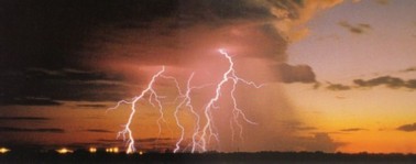
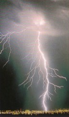
Lightning occurs when there is an electrical discharge within, or around, a thunderstorm. Cloud-to-ground lightning occurs when the electrical charge travels between a negatively charged cloud base and the positively charged ground. This is the most spectacular variation of lightning, forming brilliant, jagged bolts between the sky and the ground. Each lightning stroke lasts a fraction of a second. Sometimes a number of strokes is needed to discharge the electrical build-up, giving the lightning a flickering appearance. Often the main stroke combines with smaller offshoots that discharge into the air or inside the cloud. The ground, and almost any solid object in connection with the ground, will conduct electricity more effectively than air. This means that elevated landmasses and tall objects such as buildings and trees are prone to strikes. Most cloud-to-ground lightning occurs from the base of a cloud. However, a rarer form, known as a positive flash, occurs when positive charges higher up in a cloud react with negative ones on the ground, sending a mighty lightning bolt from the top of the cloud to the ground. Since the path of this type of stroke is much longer, the charge has to be far more powerful.
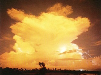
The color of lightning indicates the content
of the surrounding air. The flash will appear red
if there is rain in the cloud, and blue if there is
hail. The presence of a significant amount of
dust in the atmosphere will produce yellow
lightning. White lightning indicates low
humidity; as a result, this is the form of lightning most likely to generate fires on the ground.
Striking Out Although only about 20 percent of lightning reaches the ground, strikes occur somewhere on Earth over 100 times every second. In North America, about 400 people are struck by lightning each year, and about one in four of these strikes is fatal. There are a number of precautions you can take to minimize your chances of being hit by lightning during a storm. If possible, move indoors. When lightning strikes a building, it tends to run along plumbing and electrical circuits, so you should avoid touching metal pipes or using any electrical equipment, including telephones and computers. One of the safest places to be is inside a car, as the car's tyres provide insulation. Aircraft are also safe, because they are not in contact with the ground and therefore cannot conduct electricity. If you are caught outdoors, do not shelter beneath isolated trees, as they are favorite pathways for the lightning's leader strokes. Keep clear of metal objects such as wire fences, which can conduct electricity over considerable distances. Should your hair begin to stand on end, this may mean that you are within the area of positive charge below the cloud and that a strike is imminent. If this happens, crouch on all fours at once and keep your head low. Do not lie full-length on the ground, as this will increase your contact with any charges that may be conducted through the ground by wet soil. If someone is struck by lightning, expert medical attention should be requested at once and cardiopulmonary resuscitation attempted. The greatest myth associated with cloud-to-ground lightning is that it never strikes the same place twice. The top of the Empire State Building is struck about 500 times a year and was once struck 15 times in just 15 minutes. |

Cloud-to-cloud lightning is the most common form of lightning. Most often it occurs within a cloud, and involves electricity passing between the negatively charged base of the cloud and its positively charged upper levels. This internal lightning stroke often illuminates the cloud from within. A large flash can produce a spectacular snapshot of an entire cumulonimbus, which may remain visible for up to half a second if there is a succession of strokes up and down the leader path. Less frequently, cloud-to-cloud lightning involves an electrical discharge between opposite charges in two adjacent clouds. This will normally occur between the positively charged top of one cloud and the negatively charged base of the other. Because cloud-to-cloud lightning normally occurs at higher altitudes than cloud-to-ground lightning, it may be seen from some distance away, particularly at night. Indeed, a large cumulonimbus cloud will be visible up to 200 miles (320 km) away if the surrounding terrain is reasonably flat. Thunder is usually audible only up to around 20 miles (32 km) from the lightning stroke that created it. This means that cloud-to-cloud lightning often appears to the observer as a "Silent Storm", with frequent flashes illuminating the sky amid eerily silent surroundings. |
This form of lightning occurs when an electrical discharge takes place between a build-up of one type of charge within a cumulonimbus cloud and an area of opposite charge in the surrounding atmosphere. This type of lightning tends not to be as powerful as cloud-to-ground lightning, and one stroke is normally enough to reduce the difference in charges to below critical levels. As a result, repeated flashes along the same cloud-to-air leader stroke are unusual. Cloud-to-air lightning normally occurs between the air and the positively charged upper regions of clouds. It does also occur in the lower parts of clouds, but usually in combination with the positive flash form of cloud-to-ground lightning, when the cloud-to-air bolts will appear as weaker offshoots from the main flash. This happens because, in the lower layers, the difference in charges between the cloud and the ground is normally greater than the difference in charges between the cloud and the surrounding air. Because cloud-to-air lightning normally occurs near the top of a cumulonimbus cloud, it is often seen from a considerable distance away. If the storm is too far away for the thunder to be heard -- usually over 20 miles (32 km) -- the observer may witness a "Silent Storm". When cloud-to-air or cloud-to-cloud lightning is obscured by clouds, the viewer may see only its flickering reflection in the adjacent clouds. Commonly known as "sheet" lightning, this is actually a simple optical effect rather than another type of lightning. |
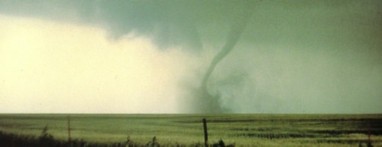
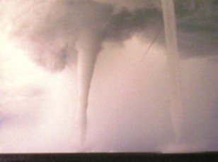
A tornado is a violently spinning vortex of air that extends from the base of a storm cloud to the ground. It is associated with severe storm activity and is one of nature's most destructive phenomena, capable of generating winds of up to 300 miles per hour (483 kph) in extreme cases. Exceptional tornadoes may last for hours and travel hundreds of miles. In the United States, the Mattoon-Charleston Tornado of 26 May 1917 covered 293 miles (471 km) in just under seven and a half hours. Most tornadoes, however, are far weaker than this, with some lasting only seconds and generating winds of less than 50 miles per hour (80 kph). Tornadoes may occur as isolated incidents or in great numbers. In the United States, the so-called "Super Outbreak" of 3-4 April 1974 saw 148 individual tornadoes devastate an area from Alabama to Michigan. Storms severe enough to generate tornadoes are most likely to occur in the middle latitudes. The United States is by far the most tornado-prone country in the world, enduring around 750 tornadoes annually. Most of these are confined to the Great Plains, with central Oklahoma having the dubious distinction of experiencing more tornadoes per acre than any other location on Earth. Tornadoes also occur regularly in Australia, and occasionally in other countries such as the United Kingdom. Tornadoes can occur at any time of the year. In the United States, there is an overall peak of activity in May and June on the Great Plains. However, tornadoes occur in different parts of the country at different times of year, with the focus of activity shifting from the Gulf in late winter to the Great Plains in midsummer, and moving southward again in fall. Tornado Alert There are two signs to look for when assessing whether a storm is severe enough to generate tornadoes. The first is the "overshoot" phenomenon, where the normally flat top of the storm's anvil displays an ominous bulge. This indicates that the upward rush of air near the center of the storm is so powerful that it has "punched" through the tropopause, bubbling up into the stratosphere. The second feature is an extensive and well-defined Mammatus Formation. A tornado's movement can be erratic, creating a cycloidal damage path (like the track a spinning top takes on a flat surface). This explains why a tornado can demolish houses either side of one that is left untouched. While this makes it difficult to tell whether you will be caught in an approaching tornado's path, there are some precautions you can take. If possible, shelter indoors, particularly in a bathroom, because this is often the strongest room in the house. If caught outside, try to shelter in a ditch. |
Waterspouts are rapidly rotating columns of air that form over lakes and oceans. They resemble tornadoes over water, and in some cases, are exactly that. However, they generally do not require severe thunderstorms to generate and sustain their motion, and are more often associated with congestus clouds. Waterspouts are classified as either tornadic or non-tornadic. Tornadic waterspouts are formed by the same mechanisms as tornadoes on land, and are relatively rare. Less intense, non-tornadic waterspouts appear to be caused by a pre-existing rotation near the surface of the water, combined with some form of updraft. This produces a funnel of rotating air that extends from the water to the base of the cloud. Non-tornadic waterspouts are most common in late summer or early fall. At this time the combination of warm sea-surface temperatures and cold air currents produces instability and strong updrafts. People often assume that a waterspout draws water up from the sea or lake below. In fact, apart from a small area of spray at the base of the spout, the water in the funnel is a result of condensation caused by very low pressure within the spiraling air mass. Waterspouts can occur in isolation or in clusters. Sometimes, the first indication of a developing waterspout is a shadow on the water where the rotating air is disturbing the surface. Once fully formed, a waterspout will tend to move slowly along a curved path for about 15 minutes until cooler air gradually enters the funnel, causing the spout to rapidly dissipate. |
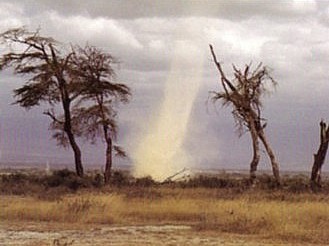
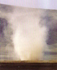
A dust devil is an upward-spiraling, dust-filled vortex
of air that may vary in height from only a few feet to
over 1000 feet (300 m). Dust devils occur mainly in desert and semi-arid areas, where the ground is dry and high surface temperatures produce strong updrafts.
Dust devils resemble mini-tornadoes, but are
generally nowhere near as intense or damaging.
They normally begin when winds blowing around local terrain features create a rotating air mass in the low or middle levels of the troposphere. This rotation then combines with strong updrafts produced by surface heating of the ground to create a powerful, rising funnel of air. As the air rises, it draws up large quantities of dust. It is this dust that renders the funnel visible. On some occasions, a cumulus cloud will form over the updraft area. This may give the appearance that the dust devil is emanating from the cloud, but this is never the case; it is the rotation in the surrounding air mass that generates the funnel. The presence of the cloud is, however, an indication that the initial updraft was relatively powerful, and the most intense dust devils are often associated with a cumulus cloud. Particularly powerful devils have been known to rip the roof off a house or flip over a car, but normally dust devils pose little threat to life or property. |
A microburst is a brief, powerful gust of wind that appears to radiate from a central point on the ground. It is caused by strong downdrafts that form in the central part of a congestus or cumulonimbus cloud. There are two distinct types of microburst -- Dry and Wet. The dry microburst occurs in dry conditions, when a column of rain falls into a layer of dry air beneath the cloud, and immediately begins to evaporate. Since evaporation produces cooling, this accelerates the downward motion of the air column, producing a powerful gust of wind that spreads in all directions. Where there is warm air near the ground, this will tend to rise and counter the downdraft. However, the descending air may still reach the surface with some velocity. Because the precipitation usually evaporates completely, the only visible sign of a dry microburst will be raised dust. The wet microburst is usually associated with heavy rain and, again, evaporation is the vital ingredient producing strong surface winds. However, in this case, the precipitation reaches the land below. Often, the wind and rain meet the ground with such force that they spread outward and upward, forming a distinctive curl. Microbursts are a major hazard for aviation as they can destabilize an aircraft that is taking off or coming in to land. This has been the cause of a number of serious accidents in the industry. |
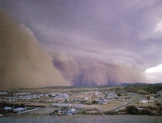
Strong winds are always capable of lifting topsoil and scattering it over large areas, but occasionally, certain conditions combine to produce huge walls of moving dust that carry thousands of tons of soil and debris to another location. Such events tend to occur after an extended drought has left the ground dry and dusty. If a vigorous cold front then moves across such an area, the ascending air at the face of the cold front may lift the topsoil, forming a huge moving wall of dust. This wall will be carried along by the front, with more soil feeding into the system as it advances. A cloud of raised dust is generally considered to be a dust storm if visibility is reduced to about half a mile (1 km). It is considered severe if visibility decreases to a quarter of a mile (0.5 km) or less. Dust can be lifted up as high as 10,000 feet (3000 m), and travel several thousand miles, remaining airborne for days. Dust storms generated by vigorous fronts over southeastern Australia have carried soil right across the Tasman Sea to New Zealand, producing dust-colored "red snow" on the New Zealand Alps. A similar phenomenon occurs in North America, when dust storms from the Plains produce dust-colored snow and rain along the Atlantic coast. Dust storms may be preceded by dust devils that have detached themselves from the main front, but these are unlikely to cause much damage. Large dust storms frequently leave behind an enormous amount of fine dust that infiltrates every corner in a house, even making its way between book pages. By far the most serious damage caused by dust storms is the removal of valuable topsoil from farmland and other areas. |
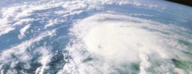
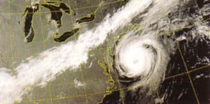
Little else in nature has the destructive force of a fully fledged hurricane. These massively powerful systems can produce sustained winds of 150 miles per hour (250 kph) with gusts of up to 190 miles per hour (300 kph), as well as intense bursts of rain and ocean surges that cause extensive flooding. While tornadoes can produce even stronger winds, they rarely last for more than a few hours. A hurricane, on the other hand, can last for weeks and cover thousands of miles. A mature hurricane consists of bands of thunderclouds spiraling around the eye -- a clear, almost calm area at the center of the storm. The whole storm system may contain hundreds of thunderstorms and measure up to 600 miles (970 km) in diameter. To qualify as a hurricane, a storm must produce winds of over 74 miles per hour (119 kph). In the Northern Hemisphere, rotating systems with lower wind speeds are known as tropical storms or tropical depressions. In the western Pacific and China Sea area, hurricanes are known as typhoons, from the Cantonese tai_fung, meaning great wind. In Australasia and countries around the Indian Ocean, the same storm systems are known as tropical cyclones. The clusters of storms that produce hurricanes occur only where sea temperatures are at least 80° F (27° C). This means that they usually originate in the tropics. To develop its distinctive rotation, the system must be at least 5 degrees from the equator, because this is where the Coriolis effect begins to have an influence. Once spinning, a storm system tends to move farther away from the equator, although it is unlikely to continue beyond 30 degrees north or south. If a hurricane returns toward the equator, it usually begins to weaken. It is impossible for a hurricane to cross the equator, because there the Coriolis effect has no impact and the hurricane will lose all its rotational energy and decay into a cluster of thunderstorms once again. Hurricane Folklore Destructive hurricanes have been recorded many times throughout history, with accounts of cities being destroyed and shipping fleets sunk by furious winds and mountainous seas. The naval fleets of the Mongol emperor, Kublai Khan, were scattered by typhoons in 1274 and again in 1281, while preparing to attack Japan. The Japanese, believing that these storms had been sent to protect their country from invasion, referred to them as divine winds, or kami-kaze.
Until recently, there was no sure way of knowing if
a hurricane was approaching the coast, but often the sea
provided some clues. A hurricane at sea produces a swell that spreads from the center of the system and often runs well ahead of the storm. Thus, if a large swell is observed, particularly when there is little local wind, this may be a sign of a hurricane. From a high vantage point, it should be possible to observe the direction from which the swell is approaching, and from this, deduce the direction in which the hurricane lies. The farther the waves are from the storm, the greater the distance between them; so, if swell waves are breaking in increasingly rapid succession as the day progresses, a hurricane may be approaching.
Modern Surveillance The development of satellite photography has allowed people to fully appreciate the spectacle and majesty of these revolving spirals of cloud and permitted scientists to monitor their movements closely. Satellite images now form the basis for hurricane forecasting around the world and,as meteorologists have become more expert at interpreting them, hurricane forecasting has continued to improve. During the local hurricane season, meteorologists receive satellite photographs hourly. They look for large clusters of thunderstorm clouds over tropical oceans, which may be embryonic hurricanes. Once such a cluster is identified, scientists monitor sequences of satellite images for any sign of rotation. If the satellite imagery reveals a rotating system moving into higher latitudes, the meteorologist looks for evidence of eye formation. Once this has been identified, and the surface wind speed has reached 74 miles per hour (119 kph), the weather service in question will then declare it to be a hurricane, and it will be officially named from the list provided by the World Meteorological Organization. A continuous watch is then kept on the hurricane, with warnings disseminated to shipping, aircraft, and the general public as long as the storm persists.
If a hurricane moves to within about 150 miles (240km) of the coastline, it is then within radar range, and can be accurately tracked. However, even at this stage, there
is an element of uncertainty as hurricanes behave unpredictably. It may continue in a straight line, or it may stall or veer. The reasons for this erratic movement are the subject of continuing research.
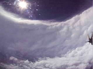
In order to study hurricanes, research scientists undertake flights into the eye of the storm (as shown in the picture on the right). The towering ramparts of cumulonimbus clouds that surround the eye may measure upto 60,000 feet high. The hurricane poses the greatest danger to human life once it reaches the coastline. Loss of life can be minimized by evacuating an area, but destruction of property is unavoidable. The surge of sea water associated with a hurricane can inundate large areas of coastal land, while high winds and further flooding from rain may cause additional damage. As the hurricane crosses the coastline and moves away from the sea -- its source of energy and moisture -- it begins to dissipate rapidly, although rains may continue for a few days. |
Acknowledgement: John W. Zillman, William J. Burroughs,
Bob Crowder, Ted Robertson, Eleanor Vallier-Talbot and Richard Whitaker.