THE AIRLINE PILOTS FORUM & RESOURCE
Fog, Dew and Frost |
| Source: Excerpt from The Book " Weather " |

|
| Dew | Radiation Fog | Advection Fog |
| Upslope Fog | Fog Stratus | Frost |
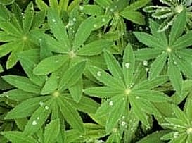
Often, after a cold, cloud free night, we wake to find the ground and other surfaces wet and glistening in the sunlight. The cause of this is a form of condensation called dew. This occurs when the temperature of the ground, or any other surface, drops low enough to cause condensation in the air immediately above it. This results in the formation of water droplets on the surface. Virtually the same process can give rise to Fog, and it is often difficult to predict when dew and fog will occur together. It is possible to have dew without fog, but it is not possible to have fog without dew. The ideal conditions for dew are a still, clear night, high humidity in the air next to the ground, and low humidity in the air above. The absence of cloud allows the ground to radiate much of the heat it has absorbed during the day and cool sufficiently for condensation to occur. The layer of moist air at ground level ensures that condensation will take place only on, or near, the surface of the ground. With fog, a deeper layer of moist air is required. In the case of dew, liquid forms because water droplets merge more readily on solid surfaces. In the air, the droplets tend to bounce off each other. Dew is often associated with cold environments, but it also occurs in hot and humid regions. In desert areas, dew formation is a vital source of water for many plants and animals. |
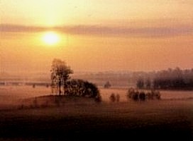
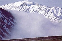
Fog is really cloud that forms near the ground, and like cloud, fog forms as a result of condensation. Probably the most common form of fog is radiation fog, so named because it is produced by radiational cooling of the ground. This happens at night, when heat absorbed by the Earth's surface during the day is radiated back into space. The highest degree of radiational cooling occurs on clear nights, when there are no clouds to reradiate the heat back to Earth. Radiational cooling produces condensation in the air layers immediately above the ground. If only a thin layer of moist air is present, Dew will form; if a thicker layer is present, radiation fog (and dew) will form. Radiation fog varies in depth from only 3 feet to about 1,000 feet. As it is always found at ground level, the most obvious effect of this type of fog is a reduction in visibility, which may drop to as low as 10 feet in thick fog. If visibility is between 0.5 and 1.25 miles (1 and 2 km), the fog is known as mist. If any smoke is present, it may combine with the fog to produce smog. Fog usually disperses soon after sunrise, as the Sun's rays gradually warm the ground. Because clear skies are required for radiation fog to occur, a fine day normally follows. In some cases, however, middle-level cloud may slide over the fog early in the day, inhibiting the clearing of the fog by the Sun. Dense radiation fogs have caused many aviation and motoring accidents over the years. Even today, despite sophisticated onboard navigation equipment, aircraft landings in thick fog are not normally permitted. |
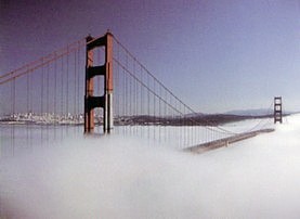
Advection fog often looks like Radiation Fog and is also the result of condensation. However, the condensation is caused not by a reduction in ground temperature, but by moist air drifting into a cold environment (or cold air moving into a moist environment). This means that advection fog can sometimes be distinguished from the normally stationary radiation fog by its horizontal motion. Since radiation fog almost always forms at night, any fog forming during the day is likely to be advection fog. Sea fogs are always advection fogs, because the oceans don't radiate heat in the same way as land and so never cool sufficiently to produce radiation fog. Fog forms at sea when warm air associated with a warm current drifts over a cold current and condensation takes place. Sometimes such fogs are drawn inland by low pressure, as often occurs on the Pacific coast of North America. Advection fog may also form when moist maritime air drifts over a cold inland area. This usually happens at night when the land temperature drops as a result of radiational cooling. Another common form of advection fog is valley fog. In this case, air that has cooled (and thus become denser) during the night drains into a valley from surrounding hillsides. Condensation then takes place, and the valley fills with fog. |
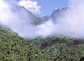
Upslope fog occurs when moist air is blown up a hillside or mountainside to a level where condensation occurs. The differences between this fog and Orographic Stratus are minor. Generally, stratus results from a significant wind, whereas the air currents that produce upslope fog are weak -- indeed, someone standing within the fog may be unaware of any air movement. Orographic stratus is more likely to form near the top of a peak, or just above it, whereas upslope fog usually begins farther down the mountain and covers a wider area. |
Upslope fog is common in all mountain ranges. Good examples occur in North America during the winter months, when cold air from low-pressure systems drifts slowly westward in the wake of a cold front. When it encounters the eastern slopes of the Rocky Mountains, the air rises and condensation occurs, causing extensive areas of upslope fog, which may run for hundreds of miles in a north-south direction. A similar process takes place in eastern Australia, when maritime air from the Tasman Sea slides inland and is lifted by the gentle slopes of the Great Dividing Range, creating extensive fog on the eastern side of these mountains. |
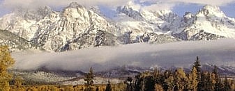
Normally, a bank of fog forms during the night and begins to disperse as the Sun rises and warms the atmosphere. In certain conditions this can give rise to a bank of fog at a higher level. This phenomenon is known as fog, or low stratus. The Sun's rays first heat the ground near the edges of the fog, causing the perimeter to dissipate. Some of the heat also penetrates the deck, warming the ground underneath. The heat from the ground then begins to evaporate the fog at low level. Thus, the fog erodes from the edges toward the center and from the underside up, resulting in a layer of fog some distance off the ground. To someone standing within the fog, this process is usually signaled by a gradual increase in visibility at ground level. However, if the deck remains intact as it rises, the Sun may stay hidden for some time. Because fog stratus forms in still conditions, there is seldom any wind at ground level and the stratus normally lifts more or less vertically as it erodes. On some occasions, however, light winds may develop soon after the bank of stratus has formed, and gently blow the fog across the ground as it is dispersing. This will tend to speed up the clearing process. Generally, fog stratus will have cleared by mid to late morning, although exceptionally thick layers may take longer to disperse. Sometimes, an increase in middle or high level cloud can inhibit the heating process at ground level and result in the fog stratus remaining intact for most of the day. This in turn will keep temperatures low at ground level. A thick layer of fog stratus may produce light drizzle, or snow in cold temperatures. However, because the fog tends to get thinner as it rises, any precipitation is generally short-lived. Extensive areas of fog stratus may obscure large areas of terrain, creating a significant aviation hazard. This can cause problems for the motorist as well, particularly in mountain areas. Valley roads may be clear, but as the motorist ascends he or she may suddenly encounter thick fog, before emerging once again into bright sunshine above the layer of fog stratus. |
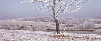
Frost, like fog, tends to occur on clear nights when the absence of cloud allows heat to rapidly radiate from the ground, resulting in a significant drop in temperature. For frost to form, the temperature must fall to below freezing (i.e. below 32° F or 0° C). True frost, known as hoar frost, occurs when a thin layer of moist air near the ground cools to below freezing and immediately forms ice crystals, without first condensing as liquid (dew). These crystals will coat any cold surface including stone, grass, leaves, berries, and even spiders' webs. Sometimes, hoar frost is so thick and white that it is mistaken for snow. The ice crystals that result from hoar frost have exquisite, jewel-like patterns that branch outward from the edges of leaves and grass stems. These intricate structures are easy to see when hoar frost forms on window panes. This normally happens on the windows of an unheated house, when the exterior temperature falls to below freezing. Because moisture levels inside the house are higher than those outside, hoar frost crystals readily form on the inside of the cold window pane, coating the glass with delightful columns, plates, and feathers of frost. If condensation takes place and dew forms before the air temperature falls below 32° F (or 0° C), the water or dew simply freezes, forming solid droplets rather than delicate ice crystals. These droplets are a form of ice rather than frost, and they occur in the same way as the ice on puddles, ponds, and lakes. When temperatures fall below freezing, the water within the leaves and stems of plants will freeze. This can cause cell damage in the plants and produce a blackening of the leaves. Although this phenomenon is known in some parts of the world as black frost, it is not always accompanied by a frost. Air with a low dew point may cool to below 32° F (0° C) without reaching saturation point, which means that no water vapor is released by the air and no real frost formation can occur. |
Acknowledgement: John W. Zillman, William J. Burroughs,
Bob Crowder, Ted Robertson, Eleanor Vallier-Talbot and Richard Whitaker.